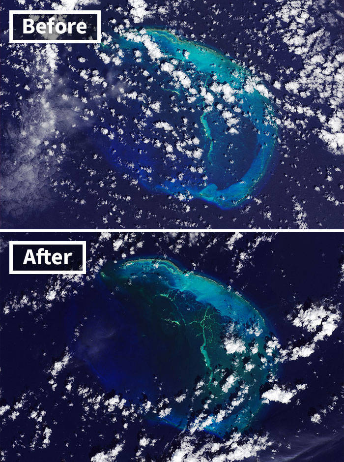
Hawaiian Island Disappears

"Until Hurricane Walaka struck in October 2018, the Northwestern Hawaiian Islands included East Island, shown in the September image. But the storm washed away most of the 11 acres of sand and gravel that constituted the island, leaving only two slivers of land, visible in the October image. East Island was part of the French Frigate Shoals, an atoll in the Papahānaumokuākea Marine National Monument."
4.

Jud 5 year s ago
Phillip,
Um, no I didn't notice that at all. One effort shows data from 2004, mainly due to 2004 being such a major year for the Muir Glacier. The rest are pretty recent. 20% are from 2020. 75% from the last 5 years.
Unless you meant that any remote sensing data is from the past, even if taken seconds ago.
Satellite data usually takes a little while to be made public due to processing requirements (e.g. ICESat-2 was launched in 2018, but some higher level products haven't been produced yet.) Then researchers need time to figure out what the data is actually showing.
5.

Sue 5 year s ago
What a shame that even when shown the data and research, some still think this is some hoax. I’m just glad I get to enjoy the planet before it’s completely destroyed. I feel sorry for future generations because it seems humanity won’t do anything until it’s too late. Nobody wants to change their habits, especially big corporations, to prevent a climate change disaster. By the time they realize it’s inevitable, it will be too late.
Also, regarding the images being a few years old, that’s obviously for security reasons. Satellite images made available to the public are never current for obvious reasons.
Also, regarding the images being a few years old, that’s obviously for security reasons. Satellite images made available to the public are never current for obvious reasons.


yep....noticed that too.
Um, no I didn't notice that at all. One effort shows data from 2004, mainly due to 2004 being such a major year for the Muir Glacier. The rest are pretty recent. 20% are from 2020. 75% from the last 5 years.
Unless you meant that any remote sensing data is from the past, even if taken seconds ago.
Satellite data usually takes a little while to be made public due to processing requirements (e.g. ICESat-2 was launched in 2018, but some higher level products haven't been produced yet.) Then researchers need time to figure out what the data is actually showing.
Also, regarding the images being a few years old, that’s obviously for security reasons. Satellite images made available to the public are never current for obvious reasons.