Drought In Lake Powell, Arizona And Utah
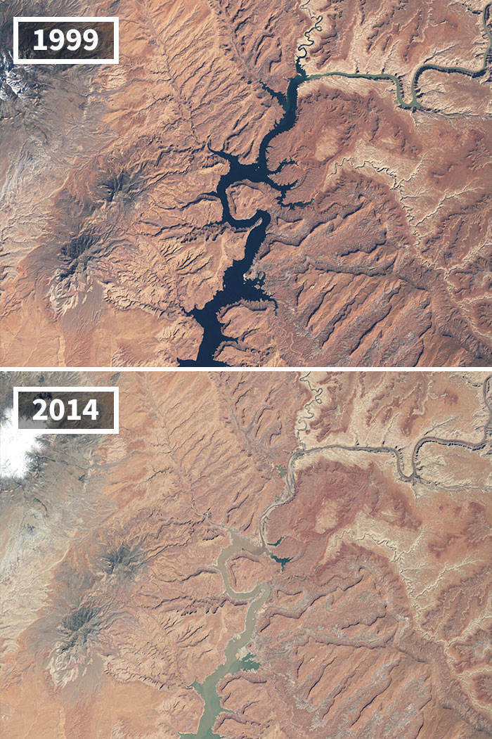
"Prolonged drought coupled with water withdrawals have caused a dramatic drop in Lake Powell's water level. These images show the northern part of the lake, which is actually a deep, narrow, meandering reservoir that extends from Arizona upstream into southern Utah. The 1999 image shows water levels near full capacity. By May 2014, the lake had dropped to 42 percent of capacity."
1

1.

Phillip 5 year s ago
Notice how all these are from the past, even a decade ago or more
1
2.
Christiana 5 year s ago
Phillip,
yep....noticed that too.
yep....noticed that too.
-1
3.
Roseann 5 year s ago
Phillip, so?
0
4.

Jud 5 year s ago
Phillip,
Um, no I didn't notice that at all. One effort shows data from 2004, mainly due to 2004 being such a major year for the Muir Glacier. The rest are pretty recent. 20% are from 2020. 75% from the last 5 years.
Unless you meant that any remote sensing data is from the past, even if taken seconds ago.
Satellite data usually takes a little while to be made public due to processing requirements (e.g. ICESat-2 was launched in 2018, but some higher level products haven't been produced yet.) Then researchers need time to figure out what the data is actually showing.
-2
5.
Sue 5 year s ago
What a shame that even when shown the data and research, some still think this is some hoax. I’m just glad I get to enjoy the planet before it’s completely destroyed. I feel sorry for future generations because it seems humanity won’t do anything until it’s too late. Nobody wants to change their habits, especially big corporations, to prevent a climate change disaster. By the time they realize it’s inevitable, it will be too late.
Also, regarding the images being a few years old, that’s obviously for security reasons. Satellite images made available to the public are never current for obvious reasons.
Also, regarding the images being a few years old, that’s obviously for security reasons. Satellite images made available to the public are never current for obvious reasons.
4
6.

Elaine 5 year s ago
Most of these have nothing to do with global warming.
3
7.
Franklin 5 year s ago
sh#tty post
1
8.

Karen 5 year s ago
#1 Arctic ice cover has increased 50% since 2012. All these photos are examples of weather, not climate.
yep....noticed that too.
Um, no I didn't notice that at all. One effort shows data from 2004, mainly due to 2004 being such a major year for the Muir Glacier. The rest are pretty recent. 20% are from 2020. 75% from the last 5 years.
Unless you meant that any remote sensing data is from the past, even if taken seconds ago.
Satellite data usually takes a little while to be made public due to processing requirements (e.g. ICESat-2 was launched in 2018, but some higher level products haven't been produced yet.) Then researchers need time to figure out what the data is actually showing.
Also, regarding the images being a few years old, that’s obviously for security reasons. Satellite images made available to the public are never current for obvious reasons.