0

1.
kaykay 15 year s ago
whats the source? thats a cool project!
thanks for showing
thanks for showing
1
2.

Fenrisulven 15 year s ago
I also want to know the source for this project. Is it based on the Panoramio photo layer in Google earth?
0
4.
GOODSTUFF4U 15 year s ago
yeah a source would be good
like the Singapore graph
did a google thing
They know by the Geo-tags that get attached to most digital pictures now. I think this was a flicker project.
http://www.flickr.com/photos/walkingsf/sets/72157624209158632/
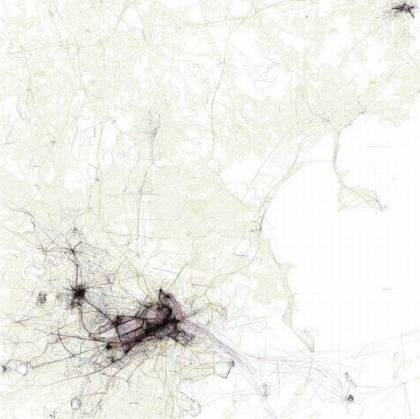
Some people interpreted the Geotaggers' World Atlas maps to be maps of tourism. This set is an attempt to figure out if that is really true. Some cities (for example Las Vegas and Venice) do seem to be photographed almost entirely by tourists. Others seem to have many pictures taken in piaces that tourists don't visit.
Blue points on the map are pictures taken by locals (people who have taken pictures in this city dated over a range of a month or more).
Red points are pictures taken by tourists (people who seem to be a local of a different city and who took pictures in this city for less than a month).
Yellow points are pictures where it can't be determined whether or not the photographer was a tourist (because they haven't taken pictures anywhere for over a month). They are probably tourists but might just not post many pictures at all.
The maps are ordered by the number of pictures taken by locals.
like the Singapore graph
did a google thing
They know by the Geo-tags that get attached to most digital pictures now. I think this was a flicker project.
http://www.flickr.com/photos/walkingsf/sets/72157624209158632/
Some people interpreted the Geotaggers' World Atlas maps to be maps of tourism. This set is an attempt to figure out if that is really true. Some cities (for example Las Vegas and Venice) do seem to be photographed almost entirely by tourists. Others seem to have many pictures taken in piaces that tourists don't visit.
Blue points on the map are pictures taken by locals (people who have taken pictures in this city dated over a range of a month or more).
Red points are pictures taken by tourists (people who seem to be a local of a different city and who took pictures in this city for less than a month).
Yellow points are pictures where it can't be determined whether or not the photographer was a tourist (because they haven't taken pictures anywhere for over a month). They are probably tourists but might just not post many pictures at all.
The maps are ordered by the number of pictures taken by locals.
0
5.
Afonso 15 year s ago
Photographer Eric Fischer, google it
thanks for showing
like the Singapore graph
did a google thing
They know by the Geo-tags that get attached to most digital pictures now. I think this was a flicker project.
http://www.flickr.com/photos/walkingsf/sets/72157624209158632/
Some people interpreted the Geotaggers' World Atlas maps to be maps of tourism. This set is an attempt to figure out if that is really true. Some cities (for example Las Vegas and Venice) do seem to be photographed almost entirely by tourists. Others seem to have many pictures taken in piaces that tourists don't visit.
Blue points on the map are pictures taken by locals (people who have taken pictures in this city dated over a range of a month or more).
Red points are pictures taken by tourists (people who seem to be a local of a different city and who took pictures in this city for less than a month).
Yellow points are pictures where it can't be determined whether or not the photographer was a tourist (because they haven't taken pictures anywhere for over a month). They are probably tourists but might just not post many pictures at all.
The maps are ordered by the number of pictures taken by locals.