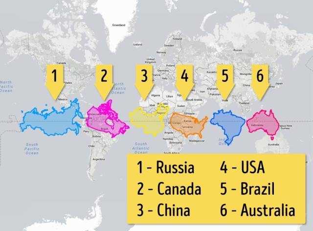
Let’s place the six largest countries along the equator. Now everything’s equal...
Russia, of course, remains huge as before, but it’s nevertheless no longer so titanically large as it first seems when at its normal latitude. Here we can also see much better just how large Australia really is.
Here are some other cartographic projections that experts use to try and provide a realistic depiction of the Earth’s geography:
0

1.
Tymusz 4 year s ago
countries don't grow or shrink. This is just the result of the projection of the map. this is stupid.
0
2.

Rhoda 3 year s ago
Interessant. Thanks!
The best is "six largest countries along the equator".
The USA are smaller, than i thought.
The best is "six largest countries along the equator".
The USA are smaller, than i thought.
0
3.

Angel 2 year s ago
There is no truth in any of this as all of these are relative to a ball earth. The earth isn't a ball so all latitudinal lines project outwards from the north pole. As there is no south pole, only a rim of ice 200 feet high circumferencing the earth, Australia is actually larger than all those other countries with the exception of maybe Russia. I'm referring to individual countries and not combined land mass such as the African continent.
The best is "six largest countries along the equator".
The USA are smaller, than i thought.